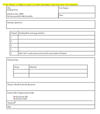
When reading a new book or article that I know will be relevant for research or class, I’ve developed a template in Google Docs that helps me keep track of my notes, and make them easy to search later (which I’ve written about and shared here).
Working on this frame is effective for me so far — and it follows me smoothly from device to device, which is key when your work happens in multiple locations. But when reading a text that is location based — at the moment, an important biography with many different geographical spaces in it — I’ve been exploring ways to easily organize and visualize this data.
When a text’s story occurs in multiple places across time, we can safely assume (usually, anyway) that the writer is familiar with these places and how they relate to each other. But with the intimacy of an author and manuscript comes a familiarity seldom so native to the reader: especially when the location is distant for readers, descriptions such as “all the way in Suffolk” carry plenty of implication, but questionable actual import.
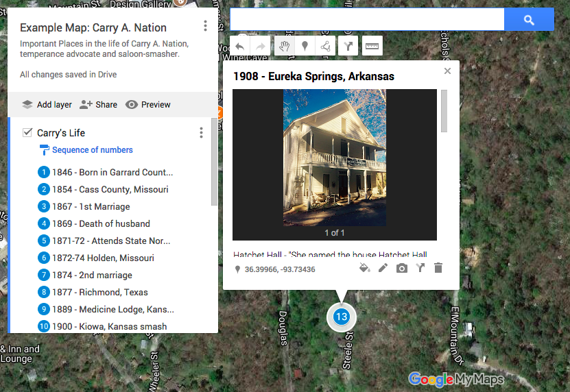
For a quick way to give more context, I’ve begun to play with the My Maps function in Google Maps. Here’s a basic tutorial. You can create a custom map, with separate layers for different characters or eras if you like, and enter locations with as little as a postcode or intersection of two known current roads. You can also add links and images to your notes for each plotted point, which can be a simple but effective way to keep track of multiple sources you’ve used in tracking your information.
Here’s an example map I put together with some locations from the life of Carry A. Nation, the temperance crusader who smashed saloons across Kansas in the early 1900s. She moved around a lot, and was arrested many places, so the geographical visualization of her travels seems useful. (As you can see, this is a quick example I’ve put together to show the way I use this feature, not really scholarly research. Contributions are very welcome!)
Improvements I would love to have:
- Easier visual transition to locations in the order you place them on your map — Prezi-like bounces? You can currently click through a list (easier on a full computer screen than mobile) or drag your mouse cursor over a list and see each spot “light up” visually as you do.
- Integration of historical mapping – locations with different names at different times